Technical University of Crete
Laboratory of Geodesy & Geomatics Enigineering
The Laboratory of Geodesy and Geomatics Engineering belongs to the Division
Exploration & Positioning of the Department of Mineral Resources Engineering
in the Technical University of Crete, Chania, Greece.
Our aim is
-
to undertake world-class research on satellite geodesy, remote sensing,
and data analysis,
-
address innovative applications,
-
provide a high quality teaching and learning environment.
We strive to become one of the top centers of excellence on Satellite Positioning,
Data Analysis and Remote Sensing.
Geodesy Section
The Geodesy section specializes in high precision geodetic and satellite
technology and applications, and is responsible for:
-
educating and training of students with the-state-of-the-art geodetic
and surveying techniques and instrumentation, such as total geodetic stations,
Global Positioning System (GPS) surveying, leveling, map projections, earths
gravity field, coordinate reference frames, etc.,
-
conducting research on :
-
high precision satellite navigation and geodetic positioning
-
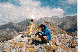
establishment of permanent GPS arrays (TUC1)
station in the Technical University of Crete has been operated since 1996),
-
Monitoring of the tectonic and geodynamic motion of the earths crust,
etc.,
-
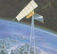
Satellite altimetry,
-
Sea level changes,
-
Data quality control, etc.
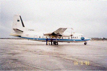
This is a photograph of the Fakker aircraft that took part in the AirGOSAT
project (Airborne Gravity field surveying for Oceanography, geodesy and
geophysics in Southern Aegean sea and the island of Crete). The project
co-ordinator was Prof. Ilias N. Tziavos, Aristotle University of Thessaloniki.
The Laboratory of Geodesy & Geomatics Engineering is an affiliate
member of the University NAVSTAR Consortium (UNAVCO,
USA) as of November 1996.
Geomatics Section
Geomatics is a modern scientific term encompassing the words of Geo and
Informatics. It refers to the integrated approach of measurement, analysis,
management, storage and display of the descriptions and location of Earth-based
data. These data come from earth-orbiting satellites, air and sea-borne
sensors and ground based instruments. Geomatics has applications in all
scientific disciplines which depend on earth data, including environmental
studies, planning, engineering, navigation, geology and geophysics, oceanography,
land development and land ownership and tourism. It is thus fundamental
to all the geoscience disciplines, which use spatially related data.
The Geomatics section of the laboratory deals with:
-
Training of undergraduate and graduate students on the science of Remote
Sensing, and Digital Image Analysis, and their application in environmental
protection matters.
-
Conducting research on:
-
Statistical analysis and quality control of remote sensing and geodetic
data.
-
Development of a System for Oil Spill and Environmental Monitoring in the
Eastern Mediterranean Using Remote Sensing and related Technologies.
-
Development of a Remote Sensing System for wild and forest fires.
-
Use of satellite and airborne sensors and images for environmental applications.
-
Exploration and positioning of mineral resources, etc.
-
Creation of databases using Geographical Information Systems (GIS).
-
Map digitising and production of Digital Elevation Models (DEM) of the
terrain.
Teaching
The Laboratory is responsible for teaching the undergraduate courses of
(1) Engineering Geodesy, (2) Remote Sensing, and (3) Environmental Remote
Sensing. On postgraduate level, it covers the courses: (1) Satellite Positioning
Systems, (2) Environmental Remote Sensing, and (3) Data Analysis.
International scientific collaboration:
In recent years the Laboratory has worked closely with colleagues at research
institutes and universities, such as the following:
-
National Research Institute for Earth Science and Disaster Prevention (NIED),
Tsukuba, Japan for quality control of GPS data, evaluation of GPS height
data, forecasting of sudden changes in the GPS signal, with applications
in earthquake studies, weather prediction, etc.
-
NASA Goddard Space Flight Center, Space Geodesy Branch, Washington, USA,
for the establishment of permanent GPS arrays for monitoring tectonic motions
of the earths surface, calibration of radar satellite altimeters, statistical
data quality control, sea level studies, climate changes, etc.
-
University of New South Wales (UNSW), Sydney, Australia, for the quality
control of the GPS measurements and the development of atmospheric and
multipath error reduction algorithms in GPS signals.
-
Foundation for Research and Technology (FORTH), Heraklion, Crete, Greece
for positioning and mapping of archeological sites employing satellites
systems and images.
-
Institute for Marine Biology, (IMBC), Heraklion, Crete, Greece for deploying
scientific and oceanographic instruments in the sea with the aid of satellite
positioning systems and for sea level studies.
-
University of Calgary, Canada for the quality control of GPS measurements.
Personnel
The TUC research group, which belongs to the Laboratory of Geodesy &
and Geomatics Engineering, consists of researchers coming from a variety
of disciplines, such as Satellite Geodesy, Precise Positioning, Navigation,
Remote Sensing, Image Analysis, Statistical Data Analysis, Oceanography
and Hydrography. The principal researchers of this Laboratory are: Stelios
Mertikas, Professor, Director of Graduate Studies, and Laboratory Director,
Mr Xen. Frantzis, Mr. Th. Papadopoulos, Mr. Ach. Tripolitsiotis, Mrs. Chr.
Avramaki, and Mrs. L. Hatziordanou.
Prof. Stelios Mertikas
received a M.Sc.E. (1983) and a Ph.D. (1987) from the Department of Geodesy
and Geomatics Engineering in the University of New Brunswick, Canada. He
has about 20-year experience with satellite precise positioning, navigation,
quality control and remote sensing. He has been involved in research programs
in North America and contributed to the development of satellite software
programs in Canada, most of which are commercially available today. He
has worked as a Lecturer and Professor at the University of New Brunswick
and the University of Toronto, Canada, respectively. He was post-doctoral
fellow at the University of Calgary, Canada in 1991 and also Honorary Visiting
Fellow at the School of Geomatic Engineering of the University of New South
Wales (UNSW), Australia during his sabbatical in 1996. He was also a Japan
Science and Technology fellow at the National Research Institute for Earth
Science and Disaster Prevention, in Japan in 2000 for 3 months. He is now
Professor at the Division of Exploration and Positioning at the Department
of Mineral Resources Engineering of the Technical University of Crete.
Mr. Xen. Frantzis is an engineer with a Masters degree from the Mineral
Resources Engineering Dept. of the Technical University of Crete. He has
been working on multipath effects of the GPS signal, the establishment
of permanent GPS arrays and evaluation of marine pollution with satellite
images. Mr. Theo Papadopoulos holds a B.Sc. in Physics with Environmental
Science from the University of Sussex and a M.Sc. in Oceanography from
the University of Southampton, UK. His interests are in sea level changes
and satellite altimetry. Mr. Ach. Tripolitsiotis holds a Dipl. Eng. in
Mineral Resources Engineering. Mrs. Chris Avramaki is a Geologist from
the Aristotle University of Thessaloniki. Her interests are on the Geographic
Information Systems and she has extensive experience from the Foundation
for Research and Technology, Crete. Mrs. Lena Hatziordanou is also a Geologist
from the Aristotle University of Thessaloniki. Detailed information is
available here.
Equipment
The Laboratory is equipped with:
-
4 high standard geodetic GPS receivers.
-
2 GPS receivers for conventional applications.
-
1 hand held GPS receiver.
-
2 radio-communication units for the transmission of differential GPS corrections.
-
2 Total geodetic stations (EDM).
-
2 Levels
-
A SUN Ultra-1 computer run on UNIX platform for the processing and archiving
GPS data and satellite images.
-
GPS Data processing software (Ashtech Office Suite, Geodyne, TEQC, etc.).
-
GIS data and satellite image processing software (Ermapper, Arc Info).
-
5 personal computers (Pentium II & III).
-
2 scanners, 2 Laser printers, 1 color printer.
-
Digital images from the following satellites: Landsat, Spot, KVR 1000,
ERS1.
Recent publications:
-
Mertikas, S, E. Pavlis, Th. Papadopoulos, X. Frantzis (2001). Preparatory
Steps for the establishment of a European radar altimeter calibration and
sea-level monitoring site for Jason, Envisat and Euro-GLOSS, International
Association of Geodesy, 2001 Scientific Assembly, 2-7 September, Budapest.
-
Topouzi, S., A. Sarris, Y. Pikoulas, S. Mertikas, X. Frantzis, A. Giourou
(2001). Ancient Mantineias Defense Network Reconsidered through a GIS
Approach, Computer Applications and Quantitative Methods in Archeology
2001, Gotland, Sweden, 25-29 April, 2001.
-
Topouzi, S., A. Tripolitsiotis, A. Sarris, S. Mertikas and S. Soetens (2001).
Compatibility Issues in Repositioning of Archeological Sites, Computer
Applications and Quantitative Methods in Archeology 2001, Gotland, Sweden,
25-29 April, 2001.
-
Pischl, W., S. Mertikas (2001). The Development of an Integrated System
for the Management of Wild Forest Fires, accepted for publication in Earth
Space Review.
-
Mertikas S. P. (2001). Automatic and Online Detection of Small but Persistent
Shifts in GPS Station Coordinates by Statistical Process Control, GPS Solutions,
Vol. 5, No.1., pp 39-50.
-
Mertikas S. P. and E. C. Pavlis (1999). A Sea-Level Monitoring and Altimeter
Calibration Site in Eastern Mediterranean, presented at the Topex/Poseidon
(NASA, CNES) Special Working Group, St Raphael, France, October 25-27,
1999 and at the American Geophysical Union (AGU) Fall meeting at San Francisco,
California, 13-17 December, 1999.
-
Mertikas, S. P. (1999). The development of a surveillance system for oil
spills in the Greek seas using Remote Sensing, Earth Space Review, Vol.
8, No.3, pp.9-18.
-
Pavlis E. C.; S. Mertikas (1999). Interdisciplinary applications of the
GPS array CRETE, Presented at the Joint Symposium on Sea-Level Changes
and Vertical Ground Movements at the 22nd General Assembly of the International
Union of Geodesy and Geophysics, July 19-30, 1999, Birmingham, United Kingdom
(Abstract & presentation only).
-
Pavlis E. C.; S. Mertikas, F. Kouroumbali and P. Drakopoulos (1998). Tectonics,
sea-level monitoring and altimeter calibration with regional GPS array,
Proceedings of the International Symposium on Marine Positioning, INSMAP
98, Nov 30-Dec 4, 1998, Melbourne, Florida, USA, edited by G. Maul.
-
Mertikas S. P. and M. Zervakis (1999). Exemplifying the Theory of Evidence
in Remote Sensing Images, International Journal of Remote Sensing, Vol.
22, No.6, pp. 1081-1095.
-
Mertikas, S. (2000). «Theory of Evidence in Remote Sensing Classification»,
Technika Chronika, Scientific Publication of TEE, Series I. Volume No.2,
pp. 73-83.
-
Mertikas, S. and S. Lahana (2000). «Methods for determining ambiguity
resolution in pahse observations of GPS. Technika Chronika, Scientific
Publication of TEE, Series I., Volume No.3.
-
Mertikas, S. and E. Bartzos (2001). «Evaluation of ionospheric effects
at the permanent GPS station of the Technical University of Crete. Technika
Chronika, Scientific Publication of TEE, Series I., Volume No.1.
-
Mertikas, S. (1999).
«Remote Sensing and Digital Image Analysis», ION Publishing
House, Athens. ISBN 960-405-949-1.
-
Sarris, A., A. Vafeidis, S. Mertikas, M. Guy, and Th. Kalpaxis (1998).
"Remote Sensing Techniques & Computer Applications for Monuments &
Site Assessment of Itanos (Eastern Crete), 26th Computer Applications in
Archaeology Conference (CAA 98), Barcelona, Spain, 25-28 March 1998.
-
Sarris, A., A. Vafeidis, S. Mertikas, M. Guy, E. Vrontaki, M. Manakou,
Th. Kalpaxis (1998). "Ancient Itanos (Erimoupolis, Lasithi): Creating an
Archaeological Site to a Remote Sensing Laboratory", 31st International
Symposium on Archaeometry (Archaeometry '98), Budapest, Hungary, April
27-May 1, 1998 (to be published in British Archeological Research International
Series).
For more information please contact:
Director & Professor Stelios P. Mertikas
Laboratory of Geodesy & Geomatics Engineering
Division of Exploration & Positioning
Departments of Mineral Resources Engineering
Technical University of Crete
Politechnioupolis,
GR-73 100, Chania, Crete,
Greece.
Tel. 28210-37629, 37633, Fax: 28210-37872
Email: mertikas@mred.tuc.gr