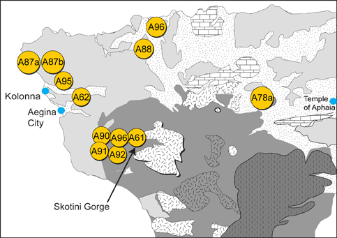
Generalized geologic map of northwestern portion of Aegina Island with clay-rich sediment sample locations (after Dietrich et al., 1991).
In the Dietrich et al. map, the northwestern part of the island is shown to consist of Pliocene volcaniclastic rocks and younger Pleistocene sediments. The locations of the Pliocene age Skotini coastal plain deposits were not specifically identified. During the summers of 2002-2004, geologic field work was conducted in the northwestern part of Aegina to locate and sample exposures of these deposits. Several exposures were located inland in the walls of large gorges that emanate from volcanic highlands to the east.
"Source Clay for Aeginetan Ware" POWERPOINT SLIDES
Abstract PDF |