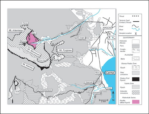
Simplified geologic map of the region surrounding the Bronze Age settlement of Lerna. The map shows the major geologic formations (after Papastamatiou et al., 1970). An X marks the locations of rock and clay-rich sediment reference samples.
Lerna lies at the southern end of the Argive Plain, a Quaternary age alluvial plain consisting of sediment derived from older sedimentary and metamorphic rocks to the west. The clay source deposits for Lernean Ware define a compositional and textural continuum that stretches northwest across the Argive Plain, and then up the Xerias River valley, terminating in a metamorphic window (Shriner, 1999). The weathering characteristics of the metamorphic rocks are such that they yield a coarser-grained sediment than the surrounding carbonates and flysch. The result is a gradation from coarse-grained clay deposits with a metamorphic fabric near the head of the Xerias River to progressively finer-grained, carbonate-rich fabric farther downstream and across the Argive Plain.
|